Introduction and background
| Content |
|---|
|
IntroductionThis Wiki is about field methods, data acquisition and modeling of contaminated limestone sites. It is part of the Region H Limestone Project, a collaboration between DTU Environment at the Technical University of Denmark and the Capital Region of Denmark (Region H). The limestone project aims at an improved understanding of contaminant transport in fractured limestone aquifers and at the identification and development of appropriate tools for the assessment of contaminated sites and the planning of remedial actions. The project involves a combination of field work, laboratory work and modeling of field data. This Wiki summarizes the major outcomes of the project and is meant as an information source about contaminant transport in fractured limestone aquifers. The goals of the Region H Limestone Project are to
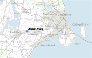
BackgroundLimestone aquifers are important drinking water resources. In Denmark, about one third of the drinking water is abstracted from limestone aquifers. Limestone aquifers provide usually high-quality drinking water, which does not need much treatment before it can be supplied to the consumers. However, aquifers are often threatened by pollutants from contaminated sites. For the protection of such drinking water resources, the understanding of the fate and transport behavior of contaminants from contaminated sites in limestone aquifers is important. This is challenging, because limestone aquifers are often heavily fractured and may contain chert layers and nodules, resulting in a complex flow and transport behavior, which is difficult to predict. Standard methods used for conventional porous-media sites without fractures (e.g. sandy aquifers) may give poor or misleading results and more advanced techniques, which consider the processes in both fractures and limestone matrix, are required. Different field methods have been developed in the past to better characterize the flow field and transport behavior in fractured aquifers. Moreover, specialized methods for determining aquifer parameters and estimating the contaminant distribution in fractured aquifers have been shown to be useful and are discussed in this Wiki. As contaminants, dissolved chlorinated solvents (PCE, TCE etc.) are considered here, but the insights can also be transferred to other dissolved contaminants. Another focus of the Limestone Wiki is on modeling techniques for contaminant transport in fractured limestone aquifers. Numerical models are essential tools for the prediction of the contaminant behavior in an aquifer and for the planning of remedial actions. They can be very useful for the planning and interpretation of field work. It is, however, important to select an appropriate model, which accounts for the actual physics and does not oversimplify the investigated system. Then, models can be very useful tools to improve the conceptual understanding and to guide with decision support for risk assessment and remedial site management. This Wiki aims at giving an overview of recent field methods and modeling tools and at evaluating their applicability in fractured limestone aquifers. It describes and evaluates some useful methods for the determination of relevant field data and for the assessment of contaminant plumes in fractured limestone aquifers. To test field methods and modeling tools and to enhance the conceptual understanding of contaminant transport in fractured limestone aquifers, a representative field site with a PCE contamination in limestone was selected. The field site is located at Akacievej in Fløng west of Copenhagen, (see map) and it is referred to as Akacievej site in the following. At the Akaceivej site, a long-term pumping test was combined with multiple tracer injections under forced gradient flow conditions. Furthermore, different hydraulic tests (borehole tests, slug tests etc.) and depth-discrete contaminant sampling methods were tested and the dynamic changes induced by (remedial) pumping were monitored. This gave some important insights and the impacts on the conceptual understanding of the processes in fractured limestone are discussed in this Wiki and in two accompanying reports. |
