The Akacievej field site
| Highlights |
|---|
|
The field site: Akacievej, HedehuseneSite historyAt the Akacievej site, a dry cleaning facility was operating in the period 1973-2003. In 2002, the site was screened for contamination by analyzing the contaminant concentrations in soil and in the pore air. This revealed high concentrations of PCE and TCE close to where dry cleaners were operating in the years between 1973 and 1975. Most of the contamination is likely to be from the operation of the dry cleaning facility and a release during a fire at the site in 1975. An array of boreholes was drilled to localize the source zone and to delineate the contaminated area. The contamination was suspected to pose a potential risk for the drinking water extraction at the Fløng waterworks, which has its closest extraction well about 600 meters north of the Akacievej site. In 2007, the most contaminated soil containing PCE as DNAPL was removed and extensive remedial activities were started. The goal of the remedial activities was to remove the hotspot and to achieve hydraulic control of the groundwater contamination. The following actions were taken:
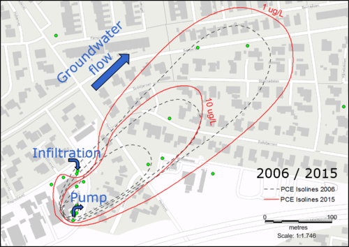
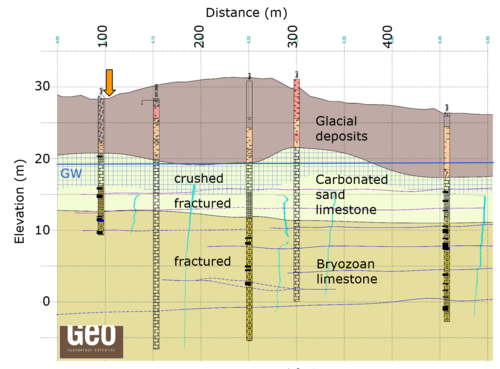
Despite potentially high flow velocities in the fractured limestone, a contaminant plume with a length of approximately 400 m had developed until 2006. It grew only little until 2015, as depicted in Figure 1, which also gives the location of the remediation system and the predominating groundwater flow direction. From 2014 to 2016, several new boreholes were drilled, and various measurements were taken at the site, including different contaminant sampling techniques, geophysical measurements and hydrogeologic analyses. In spring 2016, a long-term pumping test and several tracer tests were conducted at the site to further enhance the understanding of contaminant transport dynamics in fractured limestone. In 2018, the groundwater flow field and the contaminant distribution were measured again and simulations were carried out to investigate the mobility of the contaminant plume and the efficiency of the remediation system that has been running since 2007. GeologyA geological cross section at the Akacievej site is depicted in Figure 2 [1]. The geology consists of a calcarenithic limestone (København Kalk) on top of a bryozoan limestone (Stevns Klint formation), both with a strongly varying hardness. Due to glacial activity, the uppermost 1 to 5 meters of the limestone are crushed, below which it is fractured with flint inclusions. Most of the crushed limestone is in the carbonated sand limestone, but at some places it also penetrates into the bryozoan limestone. Bryozoan limestone often contains bank structures. However, the bryozoan limestone at the Akacievej does not show strong bank structures and is rather even, possibly because the bank structures there are long-stretched.
|
- ↑ Mosthaf et al. (2016). Pumping and tracer test in a limestone aquifer and modeling interpretation. DTU Environment.

