Difference between revisions of "Model setup"
m |
m (→Model setup for fracture flow and transport in limestone aquifers - steps) |
||
| Line 20: | Line 20: | ||
Before setting up a model, it is important to define the modeling objectives. | Before setting up a model, it is important to define the modeling objectives. | ||
The choice of the model concept, model extent, modeling scale and included details should be closely linked to these objectives. | The choice of the model concept, model extent, modeling scale and included details should be closely linked to these objectives. | ||
| − | One should | + | One should aim at including the most relevant features in the model, while keeping it as simple as possible. |
The following list gives some examples for modeling objectives: | The following list gives some examples for modeling objectives: | ||
* Analyze the distribution and potential spreading of a contaminant in an aquifer | * Analyze the distribution and potential spreading of a contaminant in an aquifer | ||
| − | * Improve the understanding and predictability of contaminant | + | * Improve the understanding and predictability of contaminant transport |
* Analyze the influence of transient hydraulic conditions (annual variations, pumping in the area) on plume propagation | * Analyze the influence of transient hydraulic conditions (annual variations, pumping in the area) on plume propagation | ||
* Develop and optimize a remediation strategy for the source zone | * Develop and optimize a remediation strategy for the source zone | ||
| − | * Optimize a remediation strategy for the plume | + | * Optimize a remediation strategy for the contaminant plume |
* Improve risk assessment, e.g. for a drinking water well, in order to assess future actions | * Improve risk assessment, e.g. for a drinking water well, in order to assess future actions | ||
* Delineate the capture zone of a well | * Delineate the capture zone of a well | ||
| Line 36: | Line 36: | ||
=== Definition of the model scope === | === Definition of the model scope === | ||
<div class="mw-collapsible-content"> | <div class="mw-collapsible-content"> | ||
| − | The scale | + | The scale also depends on the modeling objectives. |
The model scope will, for example, be different for the prediction of the spreading of an entire plume (large scale) and for the planning of source zone remedial actions (local scale). | The model scope will, for example, be different for the prediction of the spreading of an entire plume (large scale) and for the planning of source zone remedial actions (local scale). | ||
An important aspect when choosing the model extent is to have the boundaries sufficiently far away from the most influential features in the area, such as pumping wells. | An important aspect when choosing the model extent is to have the boundaries sufficiently far away from the most influential features in the area, such as pumping wells. | ||
| Line 42: | Line 42: | ||
It should be chosen based on physically meaningful boundaries (f.e. known head isolines or no-flow boundaries). | It should be chosen based on physically meaningful boundaries (f.e. known head isolines or no-flow boundaries). | ||
| − | + | The modeling of source zone remediation requires a different scale than the risk assessment of a contaminant plume for water works. | |
| − | The following scales can be | + | The following scales can be distinguished: |
| − | * well scale | + | * well or borehole scale |
* source zone scale | * source zone scale | ||
* intermediate scale for e.g. pumping tests | * intermediate scale for e.g. pumping tests | ||
| Line 51: | Line 51: | ||
Based on available data and modeling objectives, the model complexity has to be chosen. | Based on available data and modeling objectives, the model complexity has to be chosen. | ||
A very complex and detailed model is not appropriate if only little field data is available. | A very complex and detailed model is not appropriate if only little field data is available. | ||
| − | Then, a simple model can be applied, which can be | + | Then, a simple model can be applied, which can be improved as soon as new data is measured. |
Modeling was an integral part in the limestone project. | Modeling was an integral part in the limestone project. | ||
Initially, a rough model based on first measurements and available data was setup and used for the planning of further field work and measurements. | Initially, a rough model based on first measurements and available data was setup and used for the planning of further field work and measurements. | ||
| − | These measurements were later on used to improve the model | + | These measurements were later on used to improve the model. |
</div> | </div> | ||
</div> | </div> | ||
| Line 65: | Line 65: | ||
==== Geologic modeling ==== | ==== Geologic modeling ==== | ||
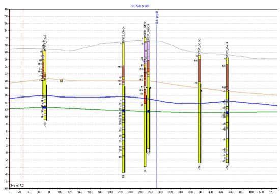
Borehole data, outcrops, geophysical measurements etc. can give valuable information about the [[ Geology and properties of limestone | geology ]] at a site. | Borehole data, outcrops, geophysical measurements etc. can give valuable information about the [[ Geology and properties of limestone | geology ]] at a site. | ||
| − | Bits of geologic knowledge can be connected to establish a geologic model, that shows different geologic layers. | + | Bits of geologic knowledge can be connected to establish a geologic model, that shows different geologic layers and relevant geologic features (like inclusions or lenses). |
Typically, these layers are characterized by different hydrogeologic properties. | Typically, these layers are characterized by different hydrogeologic properties. | ||
The geometry can be stored as a CAD interpolation of the surfaces, that delineate the geologic layers. | The geometry can be stored as a CAD interpolation of the surfaces, that delineate the geologic layers. | ||
| − | Tools like GeoScene3D can be very useful to | + | Tools like GeoScene3D can be very useful to manage borehole data and to create interpolation surfaces. |
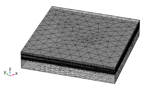
| − | The surfaces can be imported into the model later on. | + | The surfaces can be imported into the numerical model later on. |
<br clear=all> | <br clear=all> | ||
</div> | </div> | ||
| Line 94: | Line 94: | ||
<div class="mw-collapsible-content"> | <div class="mw-collapsible-content"> | ||
Boundary conditions have to be chosen according to known values, like a constant head or a known inflow. | Boundary conditions have to be chosen according to known values, like a constant head or a known inflow. | ||
| + | The most common boundary conditions are | ||
| + | * Dirichlet conditions (or first-type boundary conditions), where the primary variable is fixed to a value (e.g. fixed head or fixed concentration) | ||
| + | * Neumann conditions (or second-type boundary conditions), where the gradient of the primary variable is specified (e.g. flux across the boundary, no-flow) | ||
| + | * Cauchy conditions (or third-type boundary conditions), which sets a condition to the primary variable and it's derivative (used f.e. for the flux through a river bed). | ||
| + | The boundary conditions should be chosen according to known boundaries, such as geologic boundaries, known head isolines, known flowlines (these can be used as no-flow condition perpendicular to them). | ||
| + | Sources and sinks are employed to include e.g. withdrawal/injection at wells or groundwater recharge due to precipitation. | ||
</div> | </div> | ||
</div> | </div> | ||
Revision as of 19:24, 29 January 2018
| Highlights |
|---|
|

